Garmin’s eTrex range, renowned for its robust build quality, reliability and ease of use, has remained hugely successful ever since its introduction to the market way back in 1998.
Launched in October 2011, the new eTrex 30 (along with the other models 10 and 20) is their latest update to this stalwart brand, and it does not disappoint. Everything good about the old eTrex has been maintained, but, housed in an updated casing, improvements to some of the functionality make it more efficient, and even easier to use.
With the highest spec in the range, the eTrex 30 comes with all the features of the eTrex10 and 20 combined, along with the addition of a compass, barometric altimeter, and wireless data sharing. This new updated eTrex range has a lot to recommend it and full reviews of the eTrex 10 and 20 are also available on this site.
Fast and reliable GPS positioning
Incorporating the brand new GLONASS system with a WAAS enabled GPS receiver, eTrex devices are currently the only ones available that can track using both GPS and GLONASS satellites simultaneously. This increases the number of satellites they have access to, and therefore enables them to “lock on” to a position approx. 20% faster than using GPS alone.
The eTrex 30 can therefore be relied upon to locate your position quickly and precisely, and maintains its signal in areas of dense cover (woodland , beside tall buildings etc) and even indoors.
Clear, easy to use screen and controls
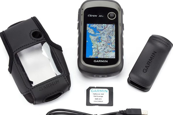
 The eTrex 30 comes with a manual, USB cord, colour screen, micro SD card and 1.7GB of internal memory. Weighing only 5oz, and fitting easily into your hand, it is one of the smallest and lightest units on the market yet manages to maintain reliable and efficient operation in all conditions.
Simply insert 2 AA batteries (rechargeable NiMH or Lithium are recommended) and you’re ready to go. The screen displays an easy to follow menu which has been adapted so you can now customise it to switch between different profiles (Geocaching, Fitness, Automotive etc). This is convenient as it allows you to have the options most applicable to your current need foremost on the screen as you turn the unit on. The device is then operated by use of a joystick on the front and 5 buttons spread on either side, and is designed with one handed operation in mind. The unit is small enough to fit easily into the palm of your hand, allowing you to operate the Zoom and Menu buttons on one side with your index and middle finger (if you’re right handed), and your thumb working the Back and Power buttons on the other side. Whether you prefer buttons or a touchscreen is a matter of personal choice- though in dusty or muddy conditions, button operation can make life easier.
It comes with a lanyard on the back, but doesn’t include a carabiner clip which I find useful and works well but is an extra cost that needs to be factored in. The casing has been improved from the old eTrex models so it feels more sturdy, and it is compatible with all Garmin spine-mounted accessories, including a bike and boat mounts.
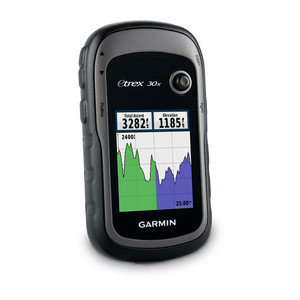
Colour screen
The device feels sturdy and robust in your hand, and is built to withstand the bumps and bangs it will inevitably receive, including being accidentally dropped in water.The screen is bright, has a good depth of colour, and works well in all weather conditions. Even in bright sunshine it compares favourably with its main competitors. It has a backlight which is a useful feature, but just note that this does zap battery power so it may be best to switch this feature on only when you need it. The screen may be on the small side (measuring 3.5 x 4.4 cm) but it is easy to read and considering the fact that the lightweight, compact nature of the machine is one of its advantages, this, I feel, is a small price to pay.
Add maps
Included is a preloaded worldwide basemap. Don’t expect too much from this however as any detail (including road systems) is non-existent. You will want to add higher scale maps.
The eTrex 30 contains a micro SD card slot, and comes with a standard 1.1 USB cable. You therefore have a choice of whether to purchase maps of your chosen area on a micro SD card, or download them from your computer. It should be noted that the lack of high speed USB 2.0 means that downloading can be slow so you will have to be patient if you’re dealing with big files.
Ordnance Survey maps, such as Garmin’s GB Discoverer (or Blue Chart for the water or City Navigator for roads) are available on micro cards. These add a significant cost (approx. £120-200 depending on the region chosen), but provide either 1:25K or 1:50K scale and allow you to dispense with a paper map with complete confidence.
The eTrex 30 is fully compatible with Garmin’s BirdsEye products – a map download service that provides aerial imagery and lets you download premium raster maps of a small chosen area to your device and integrate them with your existing maps. Again this involves a small extra cost but makes for an interesting and potentially very useful addition.
Also compatible are Garmin Chirp for dedicated geocachers, and Garmin Connect for sports and fitness enthusiasts.
Internal memory
The eTrex 30 has 1.7 GB of internal memory which allows you to save 2,000 waypoints and 200 routes on the machine (the track log which records where you have been, will store 10,000 points on up to 200 tracks). There is a memory expansion slot should you need it.
Excellent route, track, and waypoint management
The eTrex 30 has some excellent tools to aid management of your tracklog:
- Waypoints – project a waypoint, set proximity alerts, reposition a waypoint to your current location
- Tracks- show or hide multiple tracks on the map, view an elevation plot and give it a custom colour from a choice of 17, (the colour of an active track can also be changed)
- Routes- view a map of the entire route, edit the route, reverse it, view an elevation plot
Paperless Geocaching
If you’re wanting to use the device for geocaching, probably the most useful of all the updates on the eTrex range is the ability to download information straight from sites such as geocaching.com or Opencaching.com. This eliminates the need for manual entering of coordinates, or paper print-outs. eTrex stores and displays all the information you need, location, terrain, difficulty, hints and descriptions so you’ve got everything at your fingertips.
Excellent battery life
Garmin advertise running time as being 25 hours in battery life. In reality this is probably nearer 20 hours (particularly if using the backlight feature on the screen) but this is still more than enough for a long day out, so there’s little danger of running out of power half way through your trip. This is an advantage over the use of Geocaching apps on a smartphone, which, although convenient, do tend to eat up power, and can leave you short before you’ve found your chosen cache.
The added extras on the eTrex 30 that make it stand out from the eTrex 20 are:
- 3-axis tilt-compensated electronic compass which shows you where you are, even when standing still and without the need to hold it level. This is a great advance on previous models which you had to balance precariously to get an accurate reading, and it allows you to leave the device in your pocket and get on with what you’re doing.
- Barometric altimeter. This tracks changes in pressure to pinpoint your precise altitude. Plotting barometric pressure over time also helps you keep an eye on changing weather conditions.
- Wireless data sharing enables you to transfer data such as waypoints, tracks, routes and geocache details with other compatible Garmin devices.
The eTrex range as a whole has a deservedly fine reputation and the eTrex 30 has much to recommend it. It’s easy to operate, works both accurately and efficiently, has excellent battery life, and provides excellent value for money. At this higher end of the market though where more powerful navigation and more specialised spec is required, finding the right device for you depends greatly on individual needs and preference. Although more costly (which in itself is a big decisive factor) the Oregon 550 and GPSMAP 62s are strong contenders, and it is worth reading the reviews on these devices also available on this site before making a decision.